UK Climate Hazard Map for Heritage
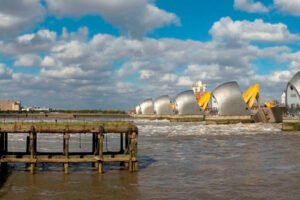
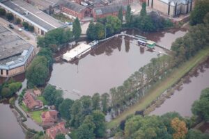
This project delivered a consistent baseline of climate and natural hazard metrics for use in climate change risk assessments. It was part of a project building a UK-wide climate hazard map providing current and future risk data for overheating, humidity, storm damage, slope failure, flooding, soil heave/shrinkage and coastal erosion.
| This was the first UK-wide climate hazard map for heritage. It built on a National Trust project, with sustainability advisors 3keel, to develop a hazard map for England, Wales and Northern Ireland. The four UK nations collaborated and commissioned 3Keel to develop the map further, including a second phase (version 1.5) with an additional 16 hazards, extending its reach to include Scotland. The intention is that as new data become available, the ‘UK Climate Hazard Map for Heritage’ will be updated. Building on UK-wide collaboration, there is an emerging programme of research around understanding and managing climate hazards and responses. This involves work with academic research partners including Exeter, Cardiff Metropolitan and Reading universities. The programme aims to develop a UK-wide understanding of: climate change hazards; the vulnerabilities of heritage assets to climate change impacts; risk assessment; adaptation solutions for the historic environment; and to better support the UK Government as a sector. |
Project Details
Location: United Kingdom, Northern Europe, Europe
Organiser(s):
Historic England
Project partner(s): National Trust for Scotland, Royal Commission on the Ancient and Historical Monuments of Wales
Funder(s):
National Trust of England Wales & Northern Ireland, Historic England, Historic Environment Scotland, Cadw, Department for Communities, Northern Ireland
Funding received: Undisclosed
Commencement Date: 08/2016
Project Status: Completed
Project owner? Update this project